


Google Maps’ New AI Features: Transforming Interactive Mapping for Developers and Users
Google Maps is stepping into the future with groundbreaking artificial intelligence (AI) features poised to revolutionize how developers and users interact with mapping data. The introduction of a builder agent and a Model Context Protocol (MCP) server aims to enhance creative capabilities, allowing for the development of interactive projects using Google Maps data and coding skills. With these updates powered by Google’s innovative Gemini models, the versatility of Google Maps is expanding significantly.
- Google Maps’ New AI Features: Transforming Interactive Mapping for Developers and Users
- Builder Agent: Crafting Interactive Prototypes with Text Prompts
- Customization with the Styling Agent
- Grounding Lite: Tailoring AI Models to External Data
- Code Assistant Toolkit: Enhancing Developer Efficiency
- Enhancements for Consumers: AI-Powered Navigation and Alerts
- Visual Insights: Examples of New Features in Action
Builder Agent: Crafting Interactive Prototypes with Text Prompts
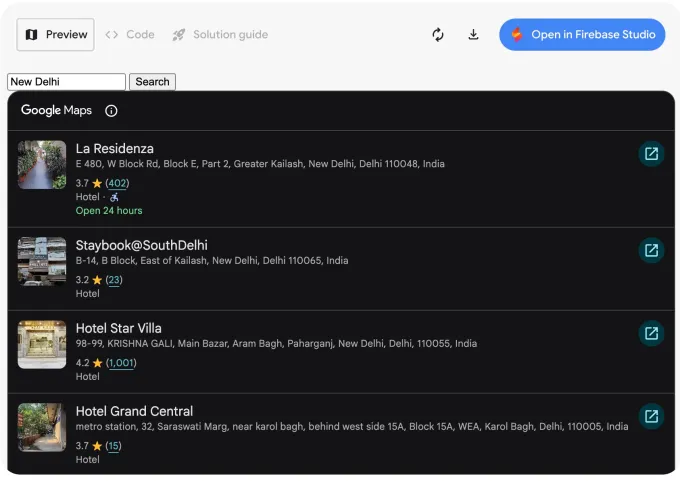
At the heart of these new tools is the builder agent, which empowers users to create interactive map-based prototypes simply by describing their ideas in text. This functionality mirrors other coding platforms, yet it focuses specifically on mapping capabilities. For example, one can easily input requests like "create a Street View tour of a city" or "list pet-friendly hotels in the city," and the tool will generate the necessary code.
Once the code is produced, developers can test their previews with their own API keys, export the generated code, or take advantage of Firebase Studio for further project modifications. The builder agent not only simplifies the prototyping process but also democratizes access to sophisticated mapping technologies, enabling both seasoned developers and novices to innovate seamlessly.
Customization with the Styling Agent
Alongside the builder agent, Google Maps introduces a styling agent. This feature allows users to create customized maps tailored to specific aesthetic formats or branding themes. By implementing designated color codes and styles, brands can enhance their visibility and make their maps more visually appealing to users. This customization capability plays an essential role in personalizing user experiences and adhering to corporate identity.
Grounding Lite: Tailoring AI Models to External Data
Google is also unveiling Grounding Lite, a feature aimed at enabling developers to ground their own AI models. Built on the same principles as the Gemini API, this new tool utilizes Model Context Protocol (MCP) to facilitate connections between AI assistants and external data sources. This means that AI can now respond intelligently to inquiries such as "How far is the nearest grocery store?"
More Read

Moreover, the Contextual View feature provides a low-code Google Maps component that enriches visual responses to user questions. This flexibility allows developers to present information through a list, map view, or a 3D display, effectively converting complex data into digestible visuals that enhance user comprehension and interaction.
Code Assistant Toolkit: Enhancing Developer Efficiency
Accompanying these features is a code assistant toolkit brought forth by the MCP server, which establishes a direct connection to Google Maps’ extensive technical documentation. This toolkit is invaluable for developers seeking quick answers and guidance on using the Google Maps API and data effectively. By streamlining access to resources, developers can save time and improve their workflow significantly, ensuring they spend less time troubleshooting and more time building.
In the previous month, Google also rolled out extensions for the Gemini command line tool, widening access to Maps data for developers eager to integrate mapping capabilities into their projects.
Enhancements for Consumers: AI-Powered Navigation and Alerts
While the focus on development tools is significant, Google isn’t neglecting consumer capabilities. Recent updates include enabling Gemini hands-free functionality for users navigating with Google Maps, significantly enhancing usability and safety during commutes. In India, for example, Google has taken a proactive approach by introducing incident alerts and speed limit data in select areas, helping users stay informed about their surroundings in real-time.
Visual Insights: Examples of New Features in Action
Image Credits: Google

Image Credits: Google

Image Credits: Google
The newly introduced features within Google Maps signify a robust shift towards integrating AI in practical and innovative ways. As developers and consumers alike explore these capabilities, the mapping landscape continues to evolve, underscoring Google’s commitment to providing powerful tools for interaction and engagement.
Inspired by: Source
![Understanding Minimal and Mechanistic Conditions for Behavioral Self-Awareness in Large Language Models (LLMs) – Study [2511.04875]](https://aimodelkit.com/wp-content/uploads/2025/11/1762861837_arxiv-logo-fb-150x150.png "Understanding Minimal And Mechanistic Conditions For Behavioral Self-Awareness In Large Language Models (Llms) – Study [2511.04875]")


